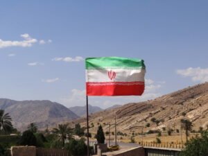

Following a prominent era in the 1950s, the Southern Iraqi Marshes ecoregion, known as the Ahwar, failed to receive significant attention during the global initiative to safeguard coastal wetlands. Despite the establishment of the Ramsar Convention aimed at protecting such areas as early as 1972, Iraq only joined the Convention in 2007, officially registering the Ahwar in 2008. This crucial step also facilitated UNESCO’s recognition of the site as a World Heritage Site in 2016.
UNESCO not only acknowledged the exceptional value of the ecoregion but also designated it as a site of both natural and cultural heritage. The designation specifically focuses on the four main marshes and incorporates the remnants of the three significant ancient cities – Eridu, Ur, and Uruk – dating back to the 4th millennium BC, forming a cohesive ecocultural biotope. Regrettably, since 1980, over forty years of conflict followed by prolonged internal instability have hindered the Southern Iraqi Marshes ecoregion from implementing necessary measures for preservation, improvement, and development.
Confronted with the looming threat of gradual decline, a collaborative Franco-Iraqi group, comprising dedicated volunteers and diverse experts, was established in association with La Goutte d’O, a French NGO specialising in hydrological initiatives with international experience, including projects in Morocco and Tunisia. Our collective deemed it imperative to uphold the commitment to include the site on the World Heritage List despite the challenges posed by decades of war and instability.
Prior to advancing any proposals or initiatives aimed at achieving this objective, it is imperative to contextualise the Marshes eco-region and compile a comprehensive inventory. The purpose of this note is to underscore the gravity of the crisis impacting the region.
Natural features
The World Heritage Sites listed in 2016 encompass an area spanning between 4,000 and 5,000 km2. Situated at the southern terminus of the expansive Iraqi plain, the ecoregion occupies a semi-desert and subtropical zone, sharing a latitude akin to cities such as Cairo and Marrakech.
Bordered by the Euphrates to the west and the Tigris to the east, both rivers traverse the entire region from north to south before converging in the Shatt al Arab, which then courses through their joint delta for nearly 200 km before reaching the Persian Gulf. Approximately 6,000 years ago, the Mesopotamian marshes began to form around this confluence, extending from Al Qurnah to the sea. Notably, the coastline’s shifting boundary over millennia has led to the creation of lagoon areas nourished by water and river sediments. Additionally, the natural evolution and, more significantly, human interventions have substantially altered riverbeds and courses.
The climatic conditions present a cause for significant concern. According to experts from the IPCC, Iraq, particularly southern Iraq, stands among the five regions worldwide most profoundly impacted by global warming. A report in the May 2022 edition of Energy Policy underscored Iraq’s possession of over ten major fossil fuel installations, all situated in close proximity to marshlands, thus constituting “climate bombs” laden with CO2 emissions.
From a soil perspective, the ecoregion’s soil composition comprises a combination of alluvial deposits left by rivers and an indigenous soil primarily consisting of clayey sand, devoid of stones, rocks, or trees. Various plant species thrive in this environment, notably the date palm, a quintessential tree emblematic of southern Iraq. Historically, bitumen has been naturally occurring in the marshes, initially utilised for domestic purposes such as caulking boats and constructing buildings. However, over the past century, this same bitumen has spurred extensive exploitation of hydrocarbons buried beneath the marshland.
From a morphological standpoint, the ecoregion of the marshes comprises three distinct components: exclusively aquatic zones characterised by brackish or saline freshwater; mixed or semi-aquatic areas, some of which may harbour light but occasionally enduring habitats; and terrestrial habitat zones encompassing notable features like the mudhif, a traditional structure of the region, alongside various activities and archaeological sites. This cohesive entity forms an amphibious territory long subjected to the vicissitudes of the rivers.
It is essential to remember that these three environments are completely intertwined and act in close interdependence. This is why they are as fragile as they are inseparable, both in terms of safeguarding them and enhancing their value and development objectives.
Located within a semi-desert subtropical zone, the ecoregion of the marshes experiences minimal local rainfall, further compounded by escalating rates of evaporation, currently estimated at around 75 cubic metres per second. Consequently, the soil is progressively desiccating and becoming increasingly saline, while the tidal influence of the Gulf Sea extends as far south as the Al Hamar marshes along the Euphrates.
Freshwater supply to the marshes primarily relies on the two rivers originating from the mountains of Turkey and Iran. These rivers historically exhibit a rainfall-nival regime owing to their respective regions of origin. This characteristic has long positioned the Ahwar as the most significant coastal wetland across Western Eurasia, thereby establishing Iraq as a region historically endowed with abundant water resources.
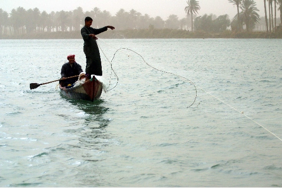
Hence, rivers hold paramount significance for biodiversity, particularly from a biological standpoint, as recognised by the Ma’dan, the marsh dwellers. Within the biosphere, the marshes harbour extensive colonies of both endemic and migratory birds, alongside sizable herds of water buffalo, integral to the sustenance and preservation of this ecosystem. Additionally, the rivers teem with shoals of fish, forming an essential component of the traditional diet of the local population.
In terms of the phytosphere, the Ahwar are distinguished by their profusion of reedbeds, historically utilised for constructing houses and boats, as well as crafting items such as the renowned reed calamus, essential for cuneiform writing. These marshes also boast a diversity of papyrus and other aquatic plants deeply ingrained in local culture. UNESCO’s decision to inscribe the marshes on the World Heritage List underscores the ecoregion’s role as an unparalleled sanctuary of biodiversity, a status that must be preserved and upheld.
Socio-cultural characteristics
UNESCO’s designation of the marshes as a World Heritage Site extends to encompass the remnants of the ancient Mesopotamian cities of Eridu, Ur, and Uruk. These cities served as the cradle of the Sumerian civilisation, which exerted profound influence and played a pivotal role in shaping the Middle East during the 4th and 3rd millennia BC. Some even regard this civilisation as the potential origin of all Indo-European civilisations.
Three crucial points merit consideration. Firstly, there is unanimous acknowledgment of the archaeological wealth present in this region and its profound significance to human history. It stands as a global treasure, rightfully evoking pride among the Iraqi people while captivating archaeology enthusiasts worldwide. Secondly, despite its invaluable nature, this heritage remains largely unexplored and shrouded in mystery. Excavations, which commenced just over a century ago, have frequently encountered obstacles, leading to challenges in its development, preservation, and utilisation. Lastly, it is essential to recognise that this cultural legacy didn’t arise by chance; rather, it emerged at the dawn of history due to the marshes’ presence and the life-sustaining waters of the rivers. The innate brilliance of these landscapes catalysed the flourishing of the Sumerian civilisation, birthing one of antiquity’s most illustrious cultures. Since time immemorial, the marshes and their adjacent sites have been inherently intertwined, forming an inseparable whole.
Water, clay, and reeds stand as the three noble yet delicate materials bestowed upon the Marshes ecoregion by the Sumerian, Akkadian, Babylonian, and Assyrian civilisations. Wood and stone were imported from elsewhere. Historically shaped by frequent river flooding and significantly altered by human intervention due to climatic fluctuations and technological advancements, the marshes region has exhibited remarkable resilience in the face of devastating conflicts and invasions.
Once home to a population numbering 300,000, the Marsh people now comprise only a few thousand individuals, their attachment to their land and traditions remaining as steadfast as ever. Despite sometimes leaning towards a subsistence economy, even verging on autarky due to challenging living conditions, these “people of the reeds” — a name symbolically fitting — remain welcoming to benevolent visitors.
With its dense and often labyrinthine landscape, the marshes have historically served as a sanctuary and refuge for the banished, exiled, fugitive, and defeated from all wars. Throughout history, tales abound of such sanctuaries, including those of royal figures like the Babylonian king Merodach-Baladan in the 8th century BC, who sought refuge in the marshes twice to evade the wrath of Assyrian kings Sargon II and Sennacherib before ultimately fleeing abroad.
Nevertheless, this sanctuary for outcasts bestowed upon the Ahwar a unique reputation, albeit one that also incurred the wrath and retaliation of those in power. For instance, during and after the war with Iran, Saddam Hussein, seeking to root out deserters and internal adversaries, made the decision to drain the marshes, demolish dykes and canals, and divert river waters for alternative purposes. Thankfully, this widespread destruction was halted before completion, yet its technical and ecological ramifications continue to exert a significant toll on the restoration and development of the ecoregion.
Furthermore, this cultural heritage must be juxtaposed with another longstanding tradition that persists to this day. The marshes region has adeptly harmonised a robust agricultural heritage with substantial urbanisation. I would venture to say that while its archaeological sites have garnered acclaim, agriculture has often been the source of its prosperity, albeit at the risk of agricultural overexploitation leading to its decline.
The marshes are surrounded by a densely urbanised geographical landscape, bordered by the major cities of Basra to the south, Nassiriya to the west, and Amarra to the east. Additionally, the site of Eridu extends slightly into the Al Muthanna region, comprising three provinces in total. Just as in the past, the close proximity and interdependence of agriculture and urban development remain both essential and challenging. Achieving synergy between these elements poses a significant challenge in safeguarding, enhancing, and sustainably developing them together.
Degradation of the biosphere
The Iraqi national authorities grapple with a multitude of political, military, security, and financial challenges, many of which are concentrated in the northern regions ravaged by ISIS. While reconstruction stands as a pressing priority, this focus leaves little room for the specific protection of the marshes ecoregion, despite the surge in oil revenues.
However, in November 2020, the Iraqi government, in collaboration with UNEP, initiated the development of a National Adaptation Plan aimed at bolstering the country’s resilience to climate change and enhancing the safeguarding of natural environments. Additionally, a program preparing for the Green Climate Fund was established in partnership with the UNDP in 2018. Nonetheless, the implementation of these initiatives progresses at a sluggish pace.
In light of the current environmental conditions in the ecoregion, all components of the biosphere undergo significant degradation. The primary threat stems from the scarcity of freshwater, as the marshes rely solely on the two rivers for its supply due to local rainfall deficiencies. However, these rivers, although traversing Iraqi territory extensively from northwest to southeast, originate from foreign and cross-border sources.
The cumulative flow of the rivers has significantly declined over time. A century ago, when Iraq was created in 1920, the flow stood at approximately 1,300 cubic metres per second. Today, it has dwindled to less than 150 cubic metres per second, marking a staggering depletion of around 90%. Despite ongoing discussions with neighbouring states Turkey and Iran, who control the rivers’ sources and tributaries, and discussions with Syria, through which the Euphrates flows, no agreements have been reached. Consequently, Iraq as a whole, and the marshes ecoregion in particular, situated at the watershed’s extreme downstream, receive only a residual flow of water.
Internally, Iraq faces additional challenges exacerbating water shortages in the ecoregion. These include the presence of numerous dams upstream, deteriorating water distribution infrastructure, and competing uses, primarily agriculture, which consumes 64% of the available fresh water volume, alongside oil extraction. However, these internal factors contributing to freshwater loss can be addressed.
The water stress index continues to rise, and alternative solutions for freshwater production, such as tapping renewable underground aquifers or desalinating seawater, are less viable in the Ahwar. Nonetheless, TotalEnergies has recently committed to constructing a seawater desalination plant in the region, offering hope for mitigating environmental risks.
Even water tables deemed renewable are no longer replenished, or only to a minimal extent. A recent example is Lake Sawa, situated outside but in close proximity to the marshlands area, approximately 20 km west of the town of Al Samawa. This saline endorheic lake, devoid of tributaries or outflows, solely relies on fissures in the bed of the Euphrates for water drainage into underground aquifers. While its water level traditionally fluctuated with the seasons, it was once frequented by enthusiasts for leisurely walks and bathing. However, since 2014, its water level has steadily declined, accompanied by a shrinking surface area. Illegally dug wells and industrial withdrawals from surrounding factories have significantly contributed to this decline. As of 2022, the lake has vanished, and the biodiversity it once supported is in decline.
Furthermore, the quality of freshwater is compromised by various forms of pollution, including industrial, domestic, agricultural, and even military sources, all of which could be addressed with adequate resources and efforts.
The desiccation of soils, exacerbated by global warming and the extensive hydrocarbon production, yields pernicious effects on both soil and air quality. Notably, soil erosion precipitates an uptick in sandstorms, known as haboob, rendering the air hazardous to breathe. Previously occurring for 50 to 60 days annually, these haboob may soon intensify to 250 or even 300 days per year.
Furthermore, the suboptimal condition of hydrocarbon extraction facilities, particularly those adjacent to the marshes, emits toxic fumes detrimental to the greenhouse effect and public health, notably methane and sulphur dioxide.
The entire eco-region of the marshes grapples with diminishing biodiversity. Avian populations dwindle, with even endemic species seeking refuge elsewhere. Victims of lethal salinisation and/or pollution, water buffalo, fish, and other emblematic species like the Iraqi otter teeter on the brink of extinction. Their decline jeopardises the entire fauna and the ecosystem services it provides.
The risk extends to the flora as well. The entire phytosphere experiences distress, affecting even the most resilient species such as reed beds, crucial components of the marsh biotope. Despite their cultural, religious, and economic significance, date palms have dwindled to half their numbers since the 1960s. Furthermore, barley, other cereals, market gardening, and crops in general are on the decline, further exacerbating the ecological challenges faced by the region.
Considering the significant human presence and cultural heritage of the marshes, it is crucial to emphasise that local society is in a state of emergency, confronted with several pressing issues:
- Depopulation resulting from individual or familial migrations, and in some cases, more extensive displacements involving entire village populations.
- Public health challenges, including food shortages and mortality rates, posing imminent threats not only to the inhabitants of the Marshes but also to the millions residing in southern Iraq.
- Various threats jeopardising the future of archaeological excavations, the preservation of discovered heritage, and the security of Sumerian sites.
- Risks of demographic shifts and security crises in the major urban centres neighbouring the marshes, as they contend with an influx of climate refugees.
Provisional assessment
This assessment underscores a crisis that extends beyond ecological concerns, necessitating decisive and immediate action to safeguard the survival of the marshes. Presently, the Iraqi authorities, preoccupied with acute geopolitical and security challenges, appear to prioritise other issues. The preservation of this ecoregion owes much to various initiatives spearheaded by Iraqi and foreign NGOs, including some from France, with support from the Embassy. Organisations such as the League for the Protection of Birds and Agronomists and Veterinarians Without Borders have played commendable roles. However, despite these salutary initiatives, experts concur that these initiatives alone will not suffice to rescue the marshes ecoregion.
Although the region has demonstrated resilience throughout its history, sustaining this capacity demands the implementation of a comprehensive action plan addressing the multifaceted causes of its current distress. Such a plan necessitates robust political commitment to its development, ensuring shared responsibility among all stakeholders on the ground, and diligent enforcement without loopholes.
Time is of the essence, as some changes may prove irreversible. Fortunately, there is no shortage of local and external goodwill. Certain preparatory or preventive measures can be quickly implemented, proving useful and necessary regardless of the overarching strategy for the future. These measures aim to slow down, and ideally halt, the processes of ecological, economic, and social degradation. Additionally, they involve preparing for the swift implementation of the comprehensive plan through training initiatives or the pursuit of essential funding.
The ecoregion of the Southern Iraqi Marshes, rightfully designated as a UNESCO World Heritage Site, merits special attention and should not be abandoned to the oblivion of geopolitics blinded by the tyranny of immediacy.
To find out more, here are several recent books and reports that address these issues:
- Mathilde Andréis, La disparition de l’eau en Irak. Aux sources d’une crise avec l’Iran et les pays voisins (“The disappearance of water in Iraq. At the root of a crisis with Iran and neighbouring countries”), L’Harmattan, 2023.
- Marcel Bazin, Tigre et Euphrate au carrefour des convoitises (“The Tigris and Euphrates at the crossroads of covetousness”), CNRS Éditions, 2021.
- The work of the World Heritage Committee. During each annual session, notably the 45th session held in Riyadh in September 2023, reports from ICOMOS and IUCN illuminate the status of certain sites and monuments listed as World Heritage. The respective states respond with explanations or specific commitments, which are then examined by the Committee to ensure follow-up to the initial inscription.